November
9, Friday

Glacier Helicopters

Our VERY YOUNG pilot
I got to sit in front with the pilot who looked like he was barely out of his teens. We took off from one of the helipads off Cook Flat Road and flew towards the town of Franz Josef. This town is bigger than the town of Fox Glacier and has about 300,000 visitors per year. It has the unenviable reputation of being NZ’s wettest township and in 1982 lost both its airstrip and bridge when a torrential 1.83 metre rainfall was recorded in 72 hours.

Franz Josef Glacier = my photo

Franz Josef Glacier = internet photo 2001

Franz Josef Glacier = internet photo 2011
The Franz Josef Glacier is 12 km long, however the above photos from the internet in 2011, show how severely it has retreated in the past 10 years. And they say there is no GLOBAL WARMING. Really!

At the top of Franz Josef Glacier

Flying over the snow and ice covered Southern Alps

A huge crevace signalling the site of a possible future avalanche

Breathtaking views

More signs of breaking ice and snow

WOW !

It is simply a spectacular view, wherever you look

Anyone want to do some mountain climbing?

We land on Fox Glacier.

“Fox Glacier is 13 km long, the longest one in Westland National Park. It comes closer to sea level than any other temperate glacier in the world.”

HELLO ! ! ! !

BEAUTIFUL !

Back on-board I take the back seat and let someone else ride in front

Taking off from Fox Glacier

Flying over the glacier, heading down off the mountain. The show and ice look like waves on an ocean.

The mountains on each side as we descend

Following the Fox River

we arrive back at the town of Fox Glacier for our landing
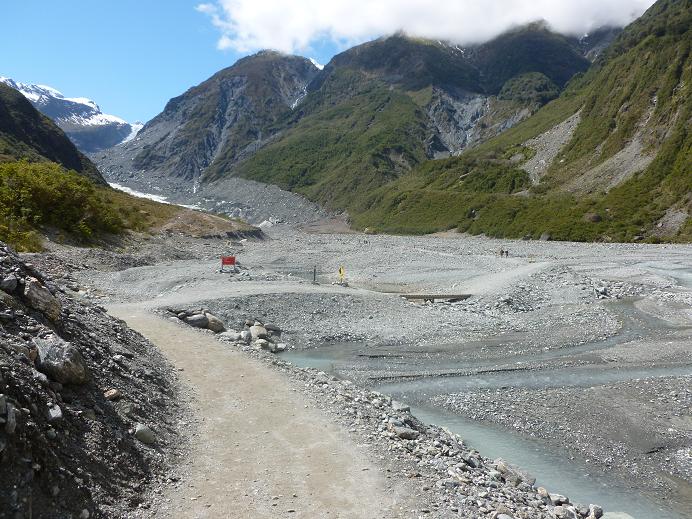
 The pathways to the bottom of Fox Glacier

It looks tiny from this end, compared to the top

Hélène: You would have loved these boulders

Had to walk on these big rocks to cross one of the streams

Wow, still a long way to go!

Finally I reach the end of the pathway. Can you see the group of people on top of the glacier?
How about the ones who have not yet reached it. Gives this shot a bit of perspective with regard to the size, doesn't it.

This was the end of the path for me however
I finally reached the “No Go Zone” where you could not pass unless you were with an experienced guide and in a group. My back would not have allowed me to climb further in any case.


Zooming in on some blue ice at the bottom of the glacier
It had taken me 40 minutes to trek up to the glacier, counting all the stops for the photos I took. My return trek only took 20 minutes, going downhill helps a lot.

The route back

Looking down from the top of the zig-zag hill at people at the bottom

The cliffs near the parking lot were absolutely spectacular. Rather than laying down flat, the rocks are standing straight up at a 180 degree angle.

I'm getting tired now.... where the h___ is the parking lot?
One more hill and I could see it in the distance. Finally got back to the car and as I was driving out I stopped to take this picture of a water fall in the distance.

I drove back through the town of Fox Glacier, down Cook Flat Road and on to Lake Matheson, where the motel manager said I would have a nice level walk around the lake with views of Mount Cook and Mount Tasman on a clear day. If you go early enough on a clear day, I’m told you can see both mountains reflected on the water of the lake.

Walking to Lake Matheson

A hanging bridge along the path

I enter a small forest and soon find myself

in a dense moss covered one

How's that for a giant fiddle head.

Lake Matheson. I would have had to walk all the way to the other end to see the view of Mount Cook, but it is getting very cloudy and the lake will obviously not provide the promised reflection. I decide to turn back and not venture any further.
Although it was still early afternoon I decided against driving to the town of Franz Josef to walk to the base of that glacier. It was starting to drizzle and I was tired from all the walking I had done. I decided to treat myself to a late lunch at a nearby restaurant that the hotel manager had recommended. They had venison on the menu and I decided to give it a try since I had seen so many deer farms.

HUGE portions, but I ate the whole thing! The meat was succulent and very tender.
I was awake early today, but did not have to hurry since
my flight was scheduled for 10 am.
Still, I went to the office at 9:30 to find out from the manager if they
would be picking me up from the motel.
He indicated that the “Glaciers Helicopter” office was just up the road
from the motel and that I could walk there in less than 5 minutes. The town of Fox Glacier consists of 3
streets, one of which is Highway # 6.
I had opted for the 40 minute ride so that I would get to
fly over both Fox Glacier & Franz
Josef Glacier as well as see the Mount Tasman (3497m) and Mount Cook in the
distance. There were two ladies from the
Nelson area, plus one young local man. 
Glacier Helicopters

Our VERY YOUNG pilot
I got to sit in front with the pilot who looked like he was barely out of his teens. We took off from one of the helipads off Cook Flat Road and flew towards the town of Franz Josef. This town is bigger than the town of Fox Glacier and has about 300,000 visitors per year. It has the unenviable reputation of being NZ’s wettest township and in 1982 lost both its airstrip and bridge when a torrential 1.83 metre rainfall was recorded in 72 hours.

Franz Josef Glacier = my photo
Franz Josef Glacier = internet photo 2001
Franz Josef Glacier = internet photo 2011
The Franz Josef Glacier is 12 km long, however the above photos from the internet in 2011, show how severely it has retreated in the past 10 years. And they say there is no GLOBAL WARMING. Really!

At the top of Franz Josef Glacier

Flying over the snow and ice covered Southern Alps

A huge crevace signalling the site of a possible future avalanche

Breathtaking views

More signs of breaking ice and snow

WOW !

It is simply a spectacular view, wherever you look

Anyone want to do some mountain climbing?

We land on Fox Glacier.

“Fox Glacier is 13 km long, the longest one in Westland National Park. It comes closer to sea level than any other temperate glacier in the world.”

HELLO ! ! ! !

BEAUTIFUL !

Back on-board I take the back seat and let someone else ride in front

Taking off from Fox Glacier

Flying over the glacier, heading down off the mountain. The show and ice look like waves on an ocean.

The mountains on each side as we descend

Following the Fox River

we arrive back at the town of Fox Glacier for our landing
After the flight, I returned to the motel to get my
gloves, ear muffs, water, walking sticks and a few other items since I was
heading for a one hour trek to the bottom of Fox Glacier. I only had a short drive from the motel to
Glacier Access Road and the parking lot.
The path was rocky, even to begin with along the Fox River, but then
zig-zagged up the bolder strewn valley.
The path flattened out for a good distance, but the last part was really
across boulders.

It looks tiny from this end, compared to the top

Hélène: You would have loved these boulders

Had to walk on these big rocks to cross one of the streams

Wow, still a long way to go!

Finally I reach the end of the pathway. Can you see the group of people on top of the glacier?
How about the ones who have not yet reached it. Gives this shot a bit of perspective with regard to the size, doesn't it.

This was the end of the path for me however
I finally reached the “No Go Zone” where you could not pass unless you were with an experienced guide and in a group. My back would not have allowed me to climb further in any case.


Zooming in on some blue ice at the bottom of the glacier
It had taken me 40 minutes to trek up to the glacier, counting all the stops for the photos I took. My return trek only took 20 minutes, going downhill helps a lot.

The route back

Looking down from the top of the zig-zag hill at people at the bottom

The cliffs near the parking lot were absolutely spectacular. Rather than laying down flat, the rocks are standing straight up at a 180 degree angle.

I'm getting tired now.... where the h___ is the parking lot?
One more hill and I could see it in the distance. Finally got back to the car and as I was driving out I stopped to take this picture of a water fall in the distance.

I drove back through the town of Fox Glacier, down Cook Flat Road and on to Lake Matheson, where the motel manager said I would have a nice level walk around the lake with views of Mount Cook and Mount Tasman on a clear day. If you go early enough on a clear day, I’m told you can see both mountains reflected on the water of the lake.

Walking to Lake Matheson

A hanging bridge along the path

I enter a small forest and soon find myself

in a dense moss covered one

How's that for a giant fiddle head.

Lake Matheson. I would have had to walk all the way to the other end to see the view of Mount Cook, but it is getting very cloudy and the lake will obviously not provide the promised reflection. I decide to turn back and not venture any further.
Although it was still early afternoon I decided against driving to the town of Franz Josef to walk to the base of that glacier. It was starting to drizzle and I was tired from all the walking I had done. I decided to treat myself to a late lunch at a nearby restaurant that the hotel manager had recommended. They had venison on the menu and I decided to give it a try since I had seen so many deer farms.

HUGE portions, but I ate the whole thing! The meat was succulent and very tender.
I went back to the motel and used the time to update my
blog.

No comments:
Post a Comment