October
8, Monday & October 9, Tuesday

 The falls however were very small since the water levels are low
 The views from Katoomba Lookout. The formation on the left is called "The Three Sisters"
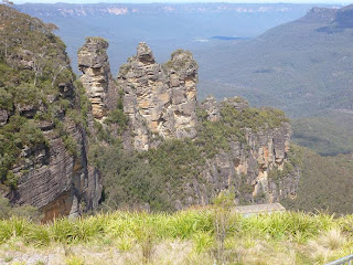
They have aboriginal names relating to a legend, but for today I renamed them: Aline, Yvette, Hélène.

Great views from both lookout levels
 While I was walking, I could hear these birds chirping and chattering, like they were having a great conversation. They were magpies. I managed to capture the sound on tape, but was not able to film them.
As I walked back toward my car, I spotted this cockatoo in the park, pecking away at bugs or worms.

 Even more impressive


Returning to Sydney

Sydney skyline is really impressive
When I got back into the city, I decided to stay on Highway 4 into the downtown core.

Driving across the ANZAC bridge
Unfortunately the signage was not clear and instead of exiting into downtown, I ended up on the Harbour Bridge. Oh Crap !

Driving across Harbour Bridge.... whether I want to or not !
Monday: Yep,
definitely over did the walking around yesterday. I had planned on either going to visit the
Australia Museum or driving out to the Blue Mountains today, but I could not
seem to get my butt out of bed. It was a
gloomy rainy day again in any case so I did not feel so guilty about staying
in.
Tuesday: Driving
out to the Blue Mountains
today. Mark, the morning manager, gave
me directions on how to get to the Great Western Highway and although I did
make a few tourist detours in the downtown core, I finally got on a road that I
THOUGHT was the Great Western Highway.
It’s always hard to tell because as I’ve mentioned before, there are no
road signs for the road you are driving on, only for the cross streets. PLUS, the street names change every few miles
in any case. I knew I was driving in the
right direction however, and the road was going straight west towards the
mountains, so I just kept going until I finally saw a road sign (Parramatta
Road, Highway 31, Great Western Highway = all the same) where the road merged
with Highway # 4 (which is also the Great Western Highway ! ! ? ?). Now I was sure I was on the right road. At one point the divided boulevard became an
expressway (Still # 4, but now called the Western Motorway and the speed
increased all the way out to foothills.
At this point the road narrowed down again, became Highway 32, but was
still called the Great Western Highway.
The base of the Blue Mountains are about 50 km outside Sydney, but I was
driving within the city almost the entire way until I reached the other side of
Parramatta (the town). This is when the drive became beautiful, meandering up
the foothills into the high country.
There were a lot of slow downs here however since they are widening the
roadway into a divided parkway.
The
Blue Mountains consist mainly of a sandstone plateau, the area is dissected by gorges up to 760 metres(2,490 ft) deep. The highest point of the range is Mount Werong at 1,215 metres (3,986 ft) above sea level. A large part of the Blue Mountains is incorporated into the Greater Blue Mountains Area World Heritage Site, consisting of seven national park areas and a conservation reserve. The Greater Blue Mountains Area was unanimously listed as a World Heritage Area by UNESCO on 29 November 2000.”
When I reached the town of Leura, I left the highway to go and see Wentworth
Falls.

Great views from the lookout at Wentworth Falls

On the way back to the Highway, I spotted a sign indicating
the “Scenic Road” which was going to be my next destination, so that was really
surendipidous. Most of it was along
Cliff Drive all the way to Katoomba
(1,010 m or 3,314 ft).


They have aboriginal names relating to a legend, but for today I renamed them: Aline, Yvette, Hélène.

Great views from both lookout levels
There was a small walking trail which I decided to follow so I could stretch my legs and get away from the crowds. I followed it for a few hundred meters until it became too steep and too uneven for me to keep going.

As I walked back toward my car, I spotted this cockatoo in the park, pecking away at bugs or worms.
I can't get used to seeing them flying around, FREE. And we keep them in cages. But they are really noisy.
I got in the car and drove around the rim of the cliff until I reached the other side.


From Eagle Hawk Lookout
I continued driving around and taking pictures. At some point I decided I had seen enough and I wanted to
get back to the Great Western Highway to make my way back to Sydney. Although I stopped to ask for directions a
few times, I never did find it and the maps I had in the car did not help SINCE
THERE WERE NO STREET NAMES ON THE STREETS !
After getting completely lost, I just happened to stumble back onto
Cliff Drive, so I decided the easiest thing to do was just retrace my entire
route. And that’s exactlly what I
did. Mind you it was a lot faster getting
back since I was no longer stopping to take photos.
Returning to Sydney

Sydney skyline is really impressive
When I got back into the city, I decided to stay on Highway 4 into the downtown core.

Driving across the ANZAC bridge
Unfortunately the signage was not clear and instead of exiting into downtown, I ended up on the Harbour Bridge. Oh Crap !

Driving across Harbour Bridge.... whether I want to or not !
Oh Well !
it may have been a tourist detour, but it was an interesting one. I ended up in North Sydney, took one of the
exits and although it took about 1 kilometer of manoeuvring through one way
streets, I finally made my way back onto Hightway 1, and crossed the bridge
again to return to Sydney, I took the first exit and got turned
around yet again. I drove around for at least 10
minutes before figuring out that I had ended up on the west side of the bridge instead of the east side. I was on Millers Point, so when I finally got
my bearings I was able to get back on Sussex Street (which I had taken this
morning) and made my way back to Oxford Street.
It did not help that in that part of the city, Oxford Street is named
Liverpool Street ! But I made it back
to the hotel. What an adventure ! I was SO TIRED from all those tourist
detours.

No comments:
Post a Comment