Sept
11, Tuesday

 At 6:15 the sun rises

The countryside around us continues to be flat scrub land.The only camels I saw were the ones at the truck stop wehre we stopped for breakfast at 8:15. As I said earlier, with AAT no food or beverages are included and everything is at an additional cost. I must say however that for $20 I ate a really good breakfast today of bacon, eggs, toast and coffee.

It's a long road to get there
No kangaroos, but hopefully I’ll see many of those in Southern Australia I’m assured. I did spot a few dingoes but never managed to get a picture. Saw a few emus in the distance. That was it for wild life. It is a wide open country of scrub land.
Uluru and Kings Canyon have only 5 “bush seasons”: Itjanu (Jan, Feb, Mar and only if it rains) overcast clouds usually bring rain. The food plants are in flower. If the rains are good, there are fruit and seeds to eat. Wanitjunkupai (Apr& May) beginning of cold weather and reptiles hibernate. Wari (May, June, July) Cold time when there is frost, mist or dew early morning. Piriyajutu (Aud & Sept) Warm steady wind from the north and west. Animals breed, Food plants flower, fruit and seed. Hibernating reptiles come back out. Good time for hunting malu (red kangaroo). Mai Wiyaringkupai (Dec) Not much food around, hottest season. Storm clouds and lightning but little rain. Time for bushfires.
 Our first view of the cliffs surrounding Kings Canyon

Here are both paths: the outer loop along the rim of the canyon, and the inner Creek Walk that I opted for.

This is the start of the rock climb for the rim walk. Doesn't look that bad?

Think again. See the people at the top of the picture? They aren't even 1/3 of the way up yet.
“Kings Canyon, in Watarrka National Park, had been known to white settlers since the mid-19th century, but it was not until John Muir first visited in 1873 that the canyon began receiving attention. {Not to be confused with John Muir who is famous for the preservation of wilderness and creation of National Parks in the western USA, but what a coincidence that both had the same name and same interests.} It is a huge canyon 270m high with Kings Creek at the bottom. The 2 km (return) and approximately 1 hour Kings Creek Walk traces the bottom of the gorge. At the end of the walk is a platform, with views of the canyon walls above. The 6 km (loop) and 3-4 hour Kings Canyon Rim Walk traces the top of the canyon. A steep climb at the beginning of the walk, which locals call "Heartbreak Hill" (or "Heart Attack Hill", due to its steepness), takes visitors up to the top, with spectacular views of the gorge below and of the surrounding landscape. About half way during the walk, a detour descends to Garden of Eden, a permanent waterhole surrounded by lush plant life. The last half of the walk passes through a large maze of weathered sandstone domes, reminiscent of the Bungle Bungle. A slow descent brings the visitor back to the starting point.”
 The path starts out very weel groomed and flat

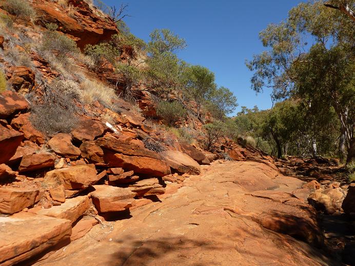
but becomes a bit more challenging as we get deeping into the canyon

Since the creek floods during every rainy season, the rock face surrounding us is worn by erosion, creating beautiful limestone layers

As I look up I can see beautiful striations in the stone

No Hélène, I did not bring one back for you, but I knew you would have LOVED this.
 We are walking in the narrower part of the canyon, it opens up into a much larger one above us.

At one point we cross the creek bed, THIS IS IT, going over bolders that have been displaced by the waters during the rainy season.


 From the bottom of the canyon, at the look out point, we can see two of the people who did the rim walk, 220 meters above us. See those two little dots at the top of the rim? Those are the two people.

We retrace our steps back to the bus. This time I'm way ahead of the pack since the others are going at the same pace as our guide..... S L O W.

At 11 am our group was back on the bus and heading for lunch. We would meet with the second group of hikers back at the restaurant. We had a leisurely 1 ½ hour wait; they only got ½ hour for their lunch.


I’m up, dressed and waiting for the bus, as
scheduled. The AAT bus pulls up only 10
minutes later than expected, so that’s good.
I don’t get to see the sun rise on Uluru however since we are heading
north towards Kings Canyon in Watarrka National Park

At 5:45 we start to see some daylight


The countryside around us continues to be flat scrub land.The only camels I saw were the ones at the truck stop wehre we stopped for breakfast at 8:15. As I said earlier, with AAT no food or beverages are included and everything is at an additional cost. I must say however that for $20 I ate a really good breakfast today of bacon, eggs, toast and coffee.

It's a long road to get there
No kangaroos, but hopefully I’ll see many of those in Southern Australia I’m assured. I did spot a few dingoes but never managed to get a picture. Saw a few emus in the distance. That was it for wild life. It is a wide open country of scrub land.
Uluru and Kings Canyon have only 5 “bush seasons”: Itjanu (Jan, Feb, Mar and only if it rains) overcast clouds usually bring rain. The food plants are in flower. If the rains are good, there are fruit and seeds to eat. Wanitjunkupai (Apr& May) beginning of cold weather and reptiles hibernate. Wari (May, June, July) Cold time when there is frost, mist or dew early morning. Piriyajutu (Aud & Sept) Warm steady wind from the north and west. Animals breed, Food plants flower, fruit and seed. Hibernating reptiles come back out. Good time for hunting malu (red kangaroo). Mai Wiyaringkupai (Dec) Not much food around, hottest season. Storm clouds and lightning but little rain. Time for bushfires.
At 9 am we arrive at Kings Canyon for our 2.6 km, one
hour walk. Our bus driver is our guide
through the canyon and he is not very energetic; though quite informative. (The guys on Emu Tours are much better.) I should point out that we were joined by a
second bus load of AAT people and we were divided into two separate walking
groups: those doing the upper rim walk
of 6 km (3.5 hours) with a steep climb up and another one back down where the
second bus would meet them.


Here are both paths: the outer loop along the rim of the canyon, and the inner Creek Walk that I opted for.

This is the start of the rock climb for the rim walk. Doesn't look that bad?

Think again. See the people at the top of the picture? They aren't even 1/3 of the way up yet.
“Kings Canyon, in Watarrka National Park, had been known to white settlers since the mid-19th century, but it was not until John Muir first visited in 1873 that the canyon began receiving attention. {Not to be confused with John Muir who is famous for the preservation of wilderness and creation of National Parks in the western USA, but what a coincidence that both had the same name and same interests.} It is a huge canyon 270m high with Kings Creek at the bottom. The 2 km (return) and approximately 1 hour Kings Creek Walk traces the bottom of the gorge. At the end of the walk is a platform, with views of the canyon walls above. The 6 km (loop) and 3-4 hour Kings Canyon Rim Walk traces the top of the canyon. A steep climb at the beginning of the walk, which locals call "Heartbreak Hill" (or "Heart Attack Hill", due to its steepness), takes visitors up to the top, with spectacular views of the gorge below and of the surrounding landscape. About half way during the walk, a detour descends to Garden of Eden, a permanent waterhole surrounded by lush plant life. The last half of the walk passes through a large maze of weathered sandstone domes, reminiscent of the Bungle Bungle. A slow descent brings the visitor back to the starting point.”
Our part of the walk along the creek bed was e x t r e m e l y s l o w.
I realized after that part of the reason for the slow start was because
some of the people who were attempting the upper walk might be turning
back. Sure enough, two people decided to
turn back and we had to wait for them to make their way back down the steep and
rocky path.


but becomes a bit more challenging as we get deeping into the canyon

Since the creek floods during every rainy season, the rock face surrounding us is worn by erosion, creating beautiful limestone layers

As I look up I can see beautiful striations in the stone


At one point we cross the creek bed, THIS IS IT, going over bolders that have been displaced by the waters during the rainy season.

And we finally arrive at the furthest point on our trail, for a vew to the "Garden of Eden" at the top, furthest end.

This is the photo from a brochure of what it looks like from the rim of the canyon during the rainy season when a waterfall comes plunging down into the canyon.

We retrace our steps back to the bus. This time I'm way ahead of the pack since the others are going at the same pace as our guide..... S L O W.

At 11 am our group was back on the bus and heading for lunch. We would meet with the second group of hikers back at the restaurant. We had a leisurely 1 ½ hour wait; they only got ½ hour for their lunch.

I decided to try the “camel burger” and an Aussie beer to go with it. It tasted pretty much like beef and I was a bit disappointed, not a hint of “gamy” taste.
Unfortunately we are doubling back for our VERY LONG trip back to Alice Springs. Let me explain the route: picture a big U with a line on the bottom towards west, something like this “ ___U” Uluru is at the left end of the underline. Alice Springs is at the top right end of the U. Kings Canyon is at the top left end of the U. Following so far? So, why could we not close the top of the U and head directly back to Alice Springs? There is a road, but it is a gravel road and ATT does not use gravel roads. Now Emu Run Tours have rugged buses, and if you do the camping tour, you get to take the short cut. Well I would not have done a camping tour, but for those of you who are interested. Something to think about. I was on the LONG route back to Alice.

The sun set as 5:54 just as we were arriving in Alice
Springs. Luckily, my hotel was one of
the first drop-off stops. That was an
extremely long day.
If I had to do it again, I would opt for the 2 days in
Uluru and not do Kings Canyon. For
those adventurous people who would love to do the rim walk, opt for a camping
tour so that you get to take the short cut back to Alice.
No comments:
Post a Comment